|

A PAPERLESS COCKPIT
++++
One way to fly paperless
Avidyne EX600
with iPad and SolidFX tablets
In late 2011, like everyone else on this planet, I bought a iPad. For my aviation ENROUTE and APPROACH charts, I installed Jeppesen MobileFD. Great application; l like it a lot. I still keep the SolidFX tablet in the cockpit with current charts.
BACKGROUND: Our Baron was among the first cockpits to adopt the superb Avidyne EX500 MultiFunction Display, and our configuration (which has now been upgraded several times) has always included Cmax -- Avidyne's variant of Jeppesen-format airport charts (Arrivals, Approaches, and Departures).
The EX500 could do it all pretty well, but with mapping, airborne radar, traffic, and charts on the MFD, I always felt that I had a bit too much information on one screen. There was too much toggling back and forth, and that busy-work always seemed to occur when I needed to be concentrating on more important tasks.
When we moved to the King Air, we had more panel real estate and a center console that had room to store a tablet, so we installed the Avidyne with its geo-referenced charts but we did not hook up our airborne radar to the MFD. The nose radar kept its own screen...so we ultimately had Traffic, Charts and Mapping on the EX600
So, the EX600 gets us halfway to a "Paperless Cockpit"...and for a year we rarely pulled out an airport chart; we used the EX500/600 screen for almost all airport charts (Exceptions being the very complex arrivals/departures at major airports) and we still carried all Jepp binders and had the paper readily available. The HI/LO-Enroutes are still nearby and handy. All I really want is a device to replace about a dozen Jepp 2" binders.
Now, having used the iPad tablet for a few years, I find that the usefulness order is that the iPad tablet running Jepp's MobileFD has become my primary chart reference. It's light and so easy to use, easy to organize, and quite reliable ... and so it's the first thing I reach for when Approach Control gives us a runway change. Normally, the EX600 gets loaded with the same chart, but occasionally I'll load an Arrival on MobileFD with the Approach on the EX600.
|
|
A Seattle-based friend, Erik Utter, asked me in late 2011:
"Your web site's Flying Paperless page mentions using the Avidyne to display charts without ever pulling out the paper. I have the same functionality with my GMX-200 and the Jepp Chartview option. I really like it, but I feel I need to have the paper out to view the profile and other parts of the chart that may not be visible on the GMX-200 without extra button presses. Perhaps I just have a training issue. Could you talk me through how you briefed and flew your approaches on just the Avidyne? Thanks!"
Sure thing. Let me try here, but as I respond, it's not "... just the Avidyne EX600..." it is "....approach briefing with any chart format in any aircraft I am flying..."
Larry Olson, Stuart Spindel, and I sta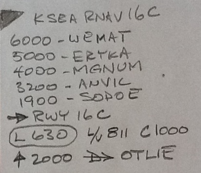 rted up the Advanced Baron Seminars at Simcom KMCO. In that group...from what source I forget...we all began to use sticky notes. These trap all the relevant approach data, the stuff we MUST get right. So, after a study of the SEATTLE RNAV (GPS) 16C approach plate, we write down: rted up the Advanced Baron Seminars at Simcom KMCO. In that group...from what source I forget...we all began to use sticky notes. These trap all the relevant approach data, the stuff we MUST get right. So, after a study of the SEATTLE RNAV (GPS) 16C approach plate, we write down:
OBSTACLE? The largest one, with the solid black arrow. For serious emergencies, we want to know if it's on the left or right side of the aircraft. On the sticky, we'll make a big black tick mark on one upper corner (to remind us where NOT to go when we are in real trouble, down much too low )
HOW LOW? ... do we go? Altitude and name of each step fix.
2300-STEPA, 1700-STEPB, etc. This list ends with Minimums (& maybe Circle Mins.)
HOW FAR?... do we go? ... to 0NM or for 1:34mins or to a MAP fix.
WHICH WAY UP? .. and to what level on the first segment of the miss. An arrow, sometimes curved to show a climbing turn, and an altitude. Maybe the next segment, too.
Then the charts are stowed. I use the iPad as my primary and handiest chart reference; the EX600 as secondary. "Stowed" means "iPad is set aside, but handy, the approach chart being displayed"; "EX600 may or may not be showing the chart plan view", unless I need the NEXRAD.
Jeppesen paper HI/LO-Enroutes back up the iPad Enroutes. I have only two Enroute data sources.
The HSI is eyeball primary, 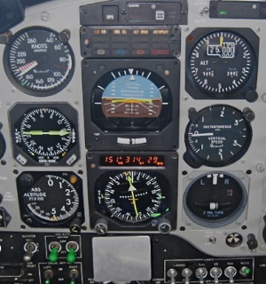 the GNS-530 is set to Arc and short-range so as to show the turns and fixes, as is the EX600 if I don't need the NEXRAD page. the GNS-530 is set to Arc and short-range so as to show the turns and fixes, as is the EX600 if I don't need the NEXRAD page.
Stickies can blow off irregular surfaces, so I went so far as to clamp an aluminum tab sitting vertical on my control column; it is at the bottom center of this image. The sticky paper goes there, in direct line of sight if I need a quick glance.
I never look at a chart inside the FAF... until I'm well cleaned up and comfortably headed back up to the first Missed Approach segment.
Does that make any sense to you? If you have a better way, I'm listening....
Erik followed up with:
"Are you saying that you fly your approach from the iPad, or that you stow the iPad? Why not fly it from the EX600? I really like my geo-referen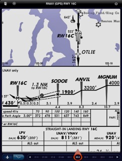 ced ownship on the GMX200 Jepp chart." ced ownship on the GMX200 Jepp chart."
Hmmmm .... I like the geo-reffed charts well enough but I have sort of stopped using that feature. I do not like it at all that a geo-reffed chart that is out of my primary scan can draw my attention AWAY from the primary business at hand. Yes, I have caught myself doing exactly that. It's a much too easy trap, I believe.
If I had the EX600 (or equivalent) sitting front and center, I'd feel ENTIRELY differently.
So I'll slew and zoom my iPad in to the last few segments of the approach and then set it on the copilot seat or center console, at KSEA it might look much like this. This huge text, I can read across the cockpit.
So what's missing, Erik? It's the FREQUENCIES. Right?
So I cheat. About 100 miles out, I'll pre-set the ATIS and GROUND on my COM2; and I'll set up COM1 on APPROACH with TOWER in the standby slot as I'm inbound in the procedure. My goal is having NEXT FREQ in the standby slot, never the LAST. I can, almost always, get to the ramp and set the chocks without looking at a chart....
...because I'm lazy and I like "simple" and "organized" and being "ahead of the aircraft". |
It's not magic and I'm no "hot stick" but it's easy and it works for me.
|
GEO-REFERENCED Charts? I leave the geo-ref OFF on Approach charts on my Jepp MobileFD. Our paper charts arent ge-reffed. I don't even want all that extra complexity. These device is a "reader"... simple, and easy to use. The iPad GPS is not designed to aviation reliability. A geo-reffed chart displayed in-panel on an EX600 or GMX-200 being supplied reliable GPS data makes a lot more sense to me.
Any questions? just give me a call, or
click on the e-mail link below.
While you are here, have a look at our horse
teams, and carriages, or take
a tour of our farm in central Virginia.
|