I really don't much like having strange
pilots in my cockpit. Most of the time, I fly by myself
and have never been trained to fly crew, and a "helpful"
pilot twisting and turning radios can be a real distraction.
Mandy was so different, but no pushover; she's a quiet,
competent aviator, and whoever flies the line with
her will love doing so. We spent quite some time on
the preflight brief talking about who would do what
and we agreed that any time either of us was uncomfortable
about anything, we would speak up with no "It's
my airplane" response allowed from me, thirty
years older than she. It seemed to work well, and
I, for one, really enjoyed the flight far more because
she was along.
So, Mandy went with me (...and she brought her boyfriend,
Tobie Comtois, don't you just HATE it when that happens?!!
). Tobie brought his camera, though, and we appreciate
the use of his images. We three left Goose Bay at
2PM to cover 1050 statute miles before dark. We headed,
at low power settings to extend our range, true north
out of Goose about 100 miles to intercept to the seacoast
near Hopedale and then we wandered, just looking around,
along the rugged coastline almost to the northern
tip of Labrador at 2000MSL down to 500MSL over the
Labrador Sea pack ice, searching for polar bears (we
saw none, but I'll bet they saw us).
The 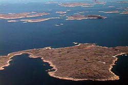 first
hour or two was similar to the southeastern Labrador
coastal terrain I had flown over the day before, and
then it began to get more rugged. We were over the
water, just off the coast, with tiny barrier islands
underneath while on our left the cliffs of the Torngat
range began to ascend from the sea. Mandy and I talked
- as pilots do - about where to put the Baron down
if we needed to and kept a "How goes it?"
log of notes, times, etc. on the sectional chart.
I haven't flown pilotage in years and it was great
to do so again. In the background, the KLN94 GPS navigator
was calculating fuel burn from the JPI EDM760 engine
monitor and giving us backup range and endurance numbers.
On one occasion, we did not like the results, so we
set "Endurance" into the GPS and reduced
power to get the endurance and reserves we were more
comfortable with.
first
hour or two was similar to the southeastern Labrador
coastal terrain I had flown over the day before, and
then it began to get more rugged. We were over the
water, just off the coast, with tiny barrier islands
underneath while on our left the cliffs of the Torngat
range began to ascend from the sea. Mandy and I talked
- as pilots do - about where to put the Baron down
if we needed to and kept a "How goes it?"
log of notes, times, etc. on the sectional chart.
I haven't flown pilotage in years and it was great
to do so again. In the background, the KLN94 GPS navigator
was calculating fuel burn from the JPI EDM760 engine
monitor and giving us backup range and endurance numbers.
On one occasion, we did not like the results, so we
set "Endurance" into the GPS and reduced
power to get the endurance and reserves we were more
comfortable with.
Then, being only 100 miles or so from
the northernmost tip of Labrador, well north of the
village of Nain and near the Hebron Mission 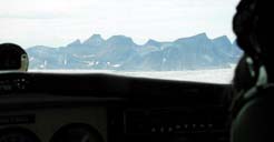 established
by the Moravians in 1782, we flew just east of a small
US radar station and its adjacent short gravel runway
sitting high on the seaside cliffs of the Ugjuktok
Fjiord above our left wing. We had descended to about
500 feet above the pack ice and were skimming the
sea, with the rubble of broken pack ice streaming
below us. As the seawater was "slick calm,"
we looked for the wakes of swimming whales and hoping.....
with really good visibility, we searched for a wide-angle
wake from a slowly swimming polar bear, but no such
luck.
established
by the Moravians in 1782, we flew just east of a small
US radar station and its adjacent short gravel runway
sitting high on the seaside cliffs of the Ugjuktok
Fjiord above our left wing. We had descended to about
500 feet above the pack ice and were skimming the
sea, with the rubble of broken pack ice streaming
below us. As the seawater was "slick calm,"
we looked for the wakes of swimming whales and hoping.....
with really good visibility, we searched for a wide-angle
wake from a slowly swimming polar bear, but no such
luck.
 A
low pressure system centered over Frobisher Bay (several
hundred miles to our north, but the weather beginning
to show its presence to us) had made us decide to
turn west over the rugged ridges to Kuujjuag on the
southern shore of Ungava Bay in far northern Quebec.
A
low pressure system centered over Frobisher Bay (several
hundred miles to our north, but the weather beginning
to show its presence to us) had made us decide to
turn west over the rugged ridges to Kuujjuag on the
southern shore of Ungava Bay in far northern Quebec.
A huge fjiord - the Nachvak - headed west into the
mountains then turned south into a blind canyon, so
we chatted how best to fly into it. The quick answer
was "Never fly up a canyon that you do not know"
so we trimmed the nose up and slowly ascended at economy
power to the mountaintops, levelling just under the
stable and level cloud bases, watching the fjiord
well below.
The flight from the coast to Kuujjuaq was at the ridgetops
and through or above the huge Korok River canyon running
mostly east-west through the Torngat range 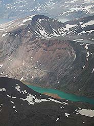 and
draining into the bay to the west. Still playing "Where
do we land now?" we spotted a number of uncharted
landing strips, mostly quite short, but perfectly
acceptable for landing if we needed to. Several had
floatplanes sitting at a dock nearby, as it was salmon
fishing season. But, getting a Baron back out again
may have been another thing altogether!
and
draining into the bay to the west. Still playing "Where
do we land now?" we spotted a number of uncharted
landing strips, mostly quite short, but perfectly
acceptable for landing if we needed to. Several had
floatplanes sitting at a dock nearby, as it was salmon
fishing season. But, getting a Baron back out again
may have been another thing altogether!
We arrived at Kuujjuaq on a nice paved runway with
a VORTAC on the field, where I paid CAN$800 to fill
up the Baron after a 4:30 leg. I'm not complaining,
though, as I was happy to have the fuel. We took a
few pictures and talked to several visitors who were
waiting, with their Inuit fishing guides, for their
airline flight to arrive to take them and their salmon
catch back to the States. Then it was two more hours
southeasterly back to Goose.
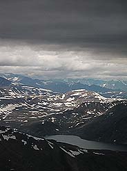
Neither Tobie, Mandy or I will ever be the same. What
a flight! A beautiful day, mostly calm over the water,
but blowing 20-30 knots in the mountains. The Torngat
Mountains were rugged, the glaciers cold-looking,
and a nasty place to have to put a plane down, but
the sweet little engines kept on purring and it was
glorious.... good golly, it was beautiful.... and
so, so desolate. It's the kind of place that makes
a pilot appreciate his maintenance team. I was glad
I had a pack, rifle, and survival gear - which I know
how to use - but I'm even happier that it stayed in
the plane.
The following day, after warm "Farewells"
to Mandy and Tobie, on the way back to Virginia from
Goose Bay, I had to have another look at Newfoundland's
, so we filed Goose direct
Deer Lake, 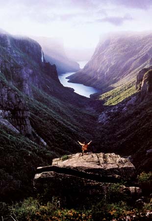 which took us over this spectacular UNESCO World Heritage
site, seen here, then via Cape Breton to Sydney, Nova
Scotia for fuel. There I met two Georgians headed
north in their Machen Aerostar who needed the same
advice I had been given by others a week before, so
Jim, Jamie and I had lunch ... (in a fast food place
that offered fingerbowls after our meal! Are
Canadians civilized or what?)....and we talked piloting;
I passed on to them my Canadian Airport directory,
and I continued through Bangor to dinner with my walking
friends in New Hampshire.
which took us over this spectacular UNESCO World Heritage
site, seen here, then via Cape Breton to Sydney, Nova
Scotia for fuel. There I met two Georgians headed
north in their Machen Aerostar who needed the same
advice I had been given by others a week before, so
Jim, Jamie and I had lunch ... (in a fast food place
that offered fingerbowls after our meal! Are
Canadians civilized or what?)....and we talked piloting;
I passed on to them my Canadian Airport directory,
and I continued through Bangor to dinner with my walking
friends in New Hampshire.
Throughout the entire trip, everyone was utterly kind
and welcoming, beginning with the US and Canadian
Customs officers who helped me with the rifle permit,
Canadian Flight Service Station employees, and pilots
who had "been there" before recommending
.
Would I go back? In a heartbeat. It was spectacular
Click to go BACK to the beginning
of the trip.
or Click here for Travel videos (QuickTime movies):
Many of these images were taken from the aircraft.
Pilots will
be interested in a few tips:
BUY YOUR CANADIAN CHARTS before you go. It is
nearly imposssible to purchase charts at Canadian
FBO's or flight schools.
Carry survival gear and know how to use it.
See:
Take a Canadian Airport directory. The directory
has tons of important information, and excellent sketches
of even the smallest airports. Also see
for Canadian airport info.
Study carefully the
for operational info. such as:
Before taxiiing anywhere, broadcast your intention
to do so on the appropriate Flight Service frequency.
At airports served by FSS you need to do this, yet
you do NOT need permission to takeoff, unless there
is a full-blown control tower operating.
Read the rules about operating in uncontrolled airspace. There is LOTS of it. See the Regulations.
If IFR in uncontrolled airspace, you may deviate heading
and altitude at will, yet you must be BACK AT your
assigned altitude when re-entering controlled airspace.
Generally, up north, monitor 126.7 all the time, and
occasionally give a position report and your intentions.
You may not get an answer, but someone may be listening.
Start making the MANDATORY calls when approaching
an airport: 20 or so miles out with your intended
runway, entering the circuit (traffic pattern), turning
base, and turning final. Around Canadian
airports they have mandatory frequencies with
rules about how to use them.
For help, call: Transport Canada's Civil Aviation
Communications Centre (800) 305-2059.
See link to
Canadian Aeronautics Act, Canadian Aviation Regulations and related safety Standards
The regulations can also be located from the home page by following the link found
on the lower left side of the screen, under the "Fast
Lane" box.
Canada Customs: See
Canadian Aeronautical Publications:
For current list of Dealers, see: Natural Resources Canada Aeronautical and Technical Services
Phone in Canada toll free (800) 465-6277
Phone from elsewhere (613) 952-7000
American Distribution of Canadian Publications:
Toll-Free(US only): (800) 543-8633
Clermont County Airport
Batavia, OH 45103
Tel: (513) 735-9100 Fax: (513) 735-9200
The US
The US