|

Is XM WX's NEXRAD "Better" than WSI NEXRAD?
Is WSI's Coverage better?
My Baron-flying friend Stuart Spindel -- with a powerful intellect and intense curiosity; he had also heard Dr. Strahle's presentation -- called me and suggested that we go "head to head". We fly identical Avidyne EX600 MFDs with nearly identical weather services, but I use WSI WX and he has XM WX. The EX600 has slew and zoom capability, so it's easy to go see what weather looks like a long ways away. Neither of us really cares who "wins" the debate about whether composite imagery or base imagery is better. Stuart and I are each very happy with the service we receive.
XM uses a mosaic of composite imagery and WSI a mosaic of base imagery. Each pair of images below was taken on May 27, 2011 to snap the same weather at the same waypoint as we were sitting in our cockpits (in Virginia and Indiana), coordinating by cell phone. All images are NorthUP (ignore the number in the top-center box, the aircraft's heading).
This was his idea. I wish I'd thought of it! YOU DECIDE !
(Note: I'm trying to figure out how to include a clickable, full size version of each image. I have several pals who are over 40.)
ITM, you can ZOOM your browser. <Command +> or <Apple+> does that.
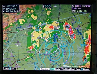
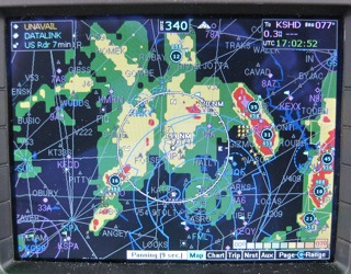
Near Athens GA
XM WX "EX600 Terrain ON"
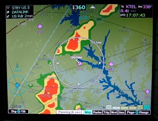
WSI WX "EX 600 Terrain OFF"
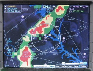
Incidentally, these images in our aircraft are crystal clear, razor sharp; we are pilots, not professional photographers! <GRIN>. We subscribe to very similar datasets. Stuart's weather data seen here (the XM Aviator package) includes lightning information from the National Lightning Detection Network, nationwide NEXRAD, coded or plain-English METARS, SIGMETS, AIRMETS, TFRs for the entire CONUS, as well as TAFs, Winds Aloft and Icing Levels, and Storm Track Vectors and the likelihood of hail within a cell. I have the nearly-identical (Avidyne Performance) package that also includes Caribbean/Mexico/Alaska coverage (all for ~$10 less, per month!)
Near Darlington SC
XM WX "EX600 Terrain ON"
WSI WX "EX 600 Terrain OFF"
Near Charlotte NC
XM WX "EX600 Terrain ON"
WSI WX "EX 600 Terrain OFF"
British Columbia
XM WX "EX 600 Terrain ON"
WSI WX "EX 600 Terrain OFF"
 |
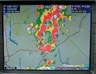
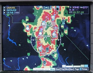
In the final analysis, there is very little difference in that BOTH services will save a lot of lives and BOTH have made our flying so much easier...but I have come to believe that WSI's airborne NEXRAD (and the related WSI weather products) is a slightly better airborne service. For one thing, the WSI subscription coverage is larger, and less costly.
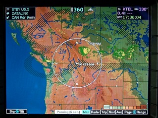
Both services offer Canadian NEXRAD. Canada updates its mosaic on a longer interval than does US NEXRAD. Here's the XM WX CANADA NEXRAD feed:
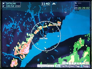
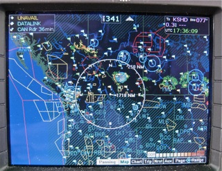
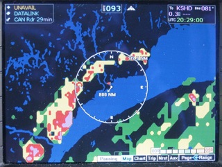
WSI WX - CANADA NEXRAD:
|
There are subtle differences in signal connectivity and coverage because of the different paths of the satellites. XM birds are geo-stationary; the three Sirius satellites fly a large figure eight...(and this will change some in the future, as the Sirius birds are shifted to geo-stationary positions).
Be also aware that our cockpit weather is often dependent on the aircraft display that's chosen to view the weather on. Both XM and WSI offer a lot of services but only certain ones are accessible on certain displays. Certified displays are often quite different from portable displays, as well.
Back to the EX600 weather...
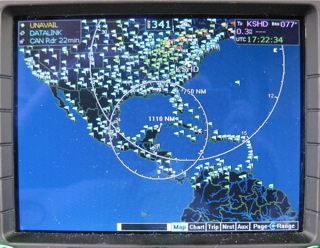
Look down south in the Caribbean. XM WX offers NO METARS and no NEXRAD in Mexico or Caribbean.
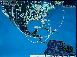
WSI WX does include the Caribbean and Mexico METARS
I sure do like the wider southern coverage areas. (Bonefish, Permit, Tarpon !)
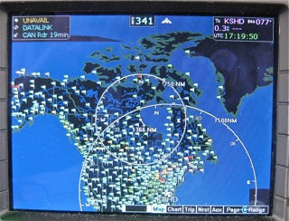
UP NORTH IN THE ARCTIC
XM WX - METARS in all of Canada, nothing in Greenland
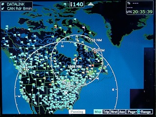
WSI WX - METARS in all of Alaska; all of Canada; and Greenland, the west coast only. (Salmon! Trout! Arctic Char! and beautiful flowers in summer. Go there.)
Alaska - Baron Services tells us that "the XM Satellite signal is not licensed by the FCC for coverage in Alaska and that there is very limited satellite signal availability in the coastal waters and onshore. As a result, XM does not provide weather data for Alaska. The majority of the XM data cuts off at the base of Alaska, with the exception of TFRs."
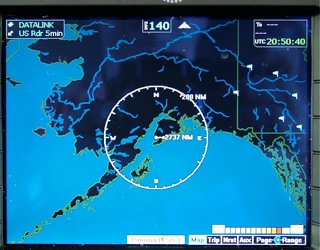
WSI WX has full METARS in Alaska. but no NEXRAD. There is a Storm Cell displayed here. Yes, there are NEXRAD sites in Alaska. 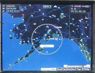 I'm not sure why WSI doesn't show any returns; where's the NEXRAD? I'm not sure why WSI doesn't show any returns; where's the NEXRAD?
WSI later reported: "Puerto Rico and Alaska NEXRAD are not a part of the NOWrad mosaic that we use and as such they are not on the broadcast.".
(HUH? We need to chat about that; it would be so easy to deliver.)
My WSI screen really ought to look more like this Garmin My Cast image: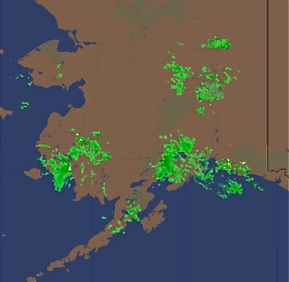
Stay with us a bit longer. There are lots more WSI and XM weather image comparisons, here.
For more on the new EX600, click here. Any questions? just give me a call, or
click on the e-mail link below.
While you are here, have a look at our horse
teams, and carriages, or take
a tour of our farm in central Virginia.
|